Bernoulli's principle relates the pressure of a fluid to its elevation and …
Bernoulli's principle relates the pressure of a fluid to its elevation and its speed. Bernoulli's equation can be used to approximate these parameters in water, air or any fluid that has very low viscosity. Students learn about the relationships between the components of the Bernoulli equation through real-life engineering examples and practice problems.
Biology is designed for multi-semester biology courses for science majors. It is …
Biology is designed for multi-semester biology courses for science majors. It is grounded on an evolutionary basis and includes exciting features that highlight careers in the biological sciences and everyday applications of the concepts at hand. To meet the needs of today’s instructors and students, some content has been strategically condensed while maintaining the overall scope and coverage of traditional texts for this course. Instructors can customize the book, adapting it to the approach that works best in their classroom. Biology also includes an innovative art program that incorporates critical thinking and clicker questions to help students understand—and apply—key concepts.
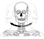
By the end of this section, you will be able to:Classify the …
By the end of this section, you will be able to:Classify the different types of joints on the basis of structureExplain the role of joints in skeletal movement
In this lesson, students learn how to determine location by triangulation. We …
In this lesson, students learn how to determine location by triangulation. We describe the process of triangulation and practice finding your location on a worksheet, in the classroom, and outdoors.
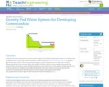
Students learn about water poverty and how water engineers can develop appropriate …
Students learn about water poverty and how water engineers can develop appropriate solutions to a problem that is plaguing nearly a sixth of the world's population. Students follow the engineering design process to design a gravity-fed water system. They choose between different system parameters such as pipe sizes, elevation differentials between entry and exit pipes, pipe lengths and tube locations to find a design that provides the maximum flow and minimum water turbidity (cloudiness) at the point of use. In this activity, students play the role of water engineers by designing and building model gravity-fed water systems, learning the key elements necessary for viable projects that help improve the lives people in developing communities.
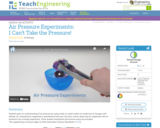
Students develop an understanding of air pressure by using candy or cookie …
Students develop an understanding of air pressure by using candy or cookie wafers to model how it changes with altitude, by comparing its magnitude to gravitational force per unit area, and by observing its magnitude with an aluminum can crushing experiment.
Students learn how engineers navigate satellites in orbit around the Earth and …
Students learn how engineers navigate satellites in orbit around the Earth and on their way to other planets in the solar system. In accompanying activities, they explore how ground-based tracking and onboard measurements are performed. Also provided is an overview of orbits and spacecraft trajectories from Earth to other planets, and how spacecraft are tracked from the ground using the Deep Space Network (DSN). DSN measurements are the primary means for navigating unmanned vehicles in space. Onboard spacecraft instruments might include optical sensors and an inertial measurement unit (IMU).
The Tippy Tap hand-washing station is an inexpensive and effective device used …
The Tippy Tap hand-washing station is an inexpensive and effective device used extensively in the developing world. One shortcoming of the homemade device is that it must be manually refilled with water and therefore is of limited use in high-traffic areas. In this activity, student teams design, prototype and test piping systems to transport water from a storage tank to an existing Tippy Tap hand-washing station, thereby creating a more efficient hand-washing station. Through this example service-learning engineering project, students learn basic fluid dynamic principles that are needed for creating efficient piping systems.
Maps are designed to allow people to travel to a new location …
Maps are designed to allow people to travel to a new location without a guide to show the way. They tell us information about areas to which we may or may not have ever been. There are many types of maps available for both recreational and professional use. A navigator uses a nautical map, while an engineer might use a surveyor's map. Maps are created by cartographers, and they can be very specific or very general, depending on their intended use. The focus of this lesson is on how to read and use topographical maps. Students will also learn to identify the common features of a map. Through the associated activities, students will learn how to use a compass to find bearing to an object on a map and in the classroom.
Students overlay USGS topographic maps into Google Earth’s satellite imagery. By analyzing …
Students overlay USGS topographic maps into Google Earth’s satellite imagery. By analyzing Denali, a mountain in Alaska, they discover how to use map scales as ratios to navigate maps, and use rates to make sense of contour lines and elevation changes in an integrated GIS software program. Students also problem solve to find potential pathways up a mountain by calculating gradients.
How does our climate affect us? How do we decide what to …
How does our climate affect us? How do we decide what to wear each day? What factors determine if our clothing choices are comfortable? What is the source of our water? Students explore characteristics that define climatic regions. They learn how tropical, desert, coastal and alpine climates result in different lifestyle, clothing, water source and food options for the people who live there. They learn that a location's latitude, altitude, land features, weather conditions, and distance from large bodies of water, determines its climate. Students discuss how engineers help us adapt to all climates by designing clothing, shelters, weather technologies and clean water systems.
No restrictions on your remixing, redistributing, or making derivative works. Give credit to the author, as required.
Your remixing, redistributing, or making derivatives works comes with some restrictions, including how it is shared.
Your redistributing comes with some restrictions. Do not remix or make derivative works.
Most restrictive license type. Prohibits most uses, sharing, and any changes.
Copyrighted materials, available under Fair Use and the TEACH Act for US-based educators, or other custom arrangements. Go to the resource provider to see their individual restrictions.